English   Română   Español   Français   Deutsch  

getamap.net

Africa

Oceania

Asia

North America

Europe

South America

Antarctica


Rivière Dauriac

(Petites Mamelles) / Guadeloupe (general)

16°3'0" N
61°37'0" W
~334m asl
13:28 (AST - UTC/GMT--4)

Riviere Dauriac (Rivière Dauriac) is a stream (class H - Hydrographic) in Guadeloupe (general), Guadeloupe [ France ] (North America) with the region font code of Americas/Western Europe. It is located at an elevation of 334 meters above sea level and its population amounts to 24,996.

Its coordinates are 16°3'0" N and 61°37'0" W in DMS (Degrees Minutes Seconds) or 16.05 and -61.6167 (in decimal degrees). Its UTM position is PC47 and its Joint Operation Graphics reference is NE20-15.

Current local time is 13:28; the sun rises at 08:53 and sets at 21:00 local time (America/Guadeloupe UTC/GMT-4). The standard time zone for Riviere Dauriac is UTC/GMT-4
In 2024 DST starts on - and ends on -.

A Stream is a body of running water moving to a lower level in a channel on land.


Country
 Advertisements:


 Advertisements:


Weather Rivière Dauriac (Cloud cover, Temperature, Wind speed and Precipitation mm probab.)

Sun


Apr 28
Clound 0-10-50-80 Lightning
 
26 °C min
28 °C max
19 km/h
Thu Jan 1

Mon


Apr 29
Clound 30-10-0-30 Lightning
~6 l/m2 43%
 
26 °C min
28 °C max
22 km/h
Thu Jan 1

Tue


Apr 30
Clound 20-20-0-20
~4 l/m2 29%
 
26 °C min
28 °C max
25 km/h
Thu Jan 1

Wed


May 1
Clound 40-10-0-10 Lightning
~8 l/m2 49%
 
26 °C min
28 °C max
23 km/h
Thu Jan 1

Thu


May 2
Clound 10-20-0-90 Lightning
~5 l/m2 44%
 
26 °C min
28 °C max
25 km/h
Thu Jan 1

Fri


May 3
Clound 40-10-70-100 Lightning
~14 l/m2 69%
 
26 °C min
28 °C max
17 km/h
Thu Jan 1

Weather Graph

Petites Mamelles (Guadeloupe (general)) 7 day forecast
 

Map and Photos Riviere Dauriac


Comments

--- There are no comments yet ---


Add a new comment:


You have to log in to add a comment!


Members area


Register

Forgot password?

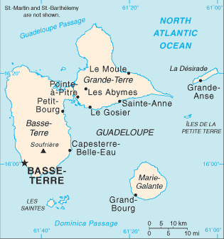
Guadeloupe [ France ] (Overseas Department):
Country Flag
Country Locator

Advertisement


GPS points near Rivière Dauriac

GPS points from Guadeloupe [ France ] (Overseas Department)

square Ravine De Sable Guadeloupe (general)

square Sable Branch Guadeloupe (general)

square Ilet Macou Guadeloupe (general)

square Anse De Colombier Guadeloupe (general)

square Lezard Point Guadeloupe (general)

square Anse Dupuy Guadeloupe (general)

square Falaise Bois Chandelle Guadeloupe (general)

square Mont De Marigot Guadeloupe (general)


viewweather.com sv.ViewWeather.com
fr.ViewWeather.com
da.ViewWeather.com
de.ViewWeather.com
es.ViewWeather.com
www.carpati.org
www.searchromania.net
Deblocari usi
es.getamap.org
fr.getamap.org
de.getamap.org
nl.getamap.org
da.getamap.org
www.getamap.org
Links
Terms of use
Privacy policy

# 0.0771 sec 

contact AT getamap.net

© 2006 - 2024  https://www.getamap.net/